Drone & Thermal Roof Inspection
Drone & Thermal Roof Inspection gets scoped from roof evidence, operating risk, Amarillo weather exposure, and the decision the building owner needs to make.
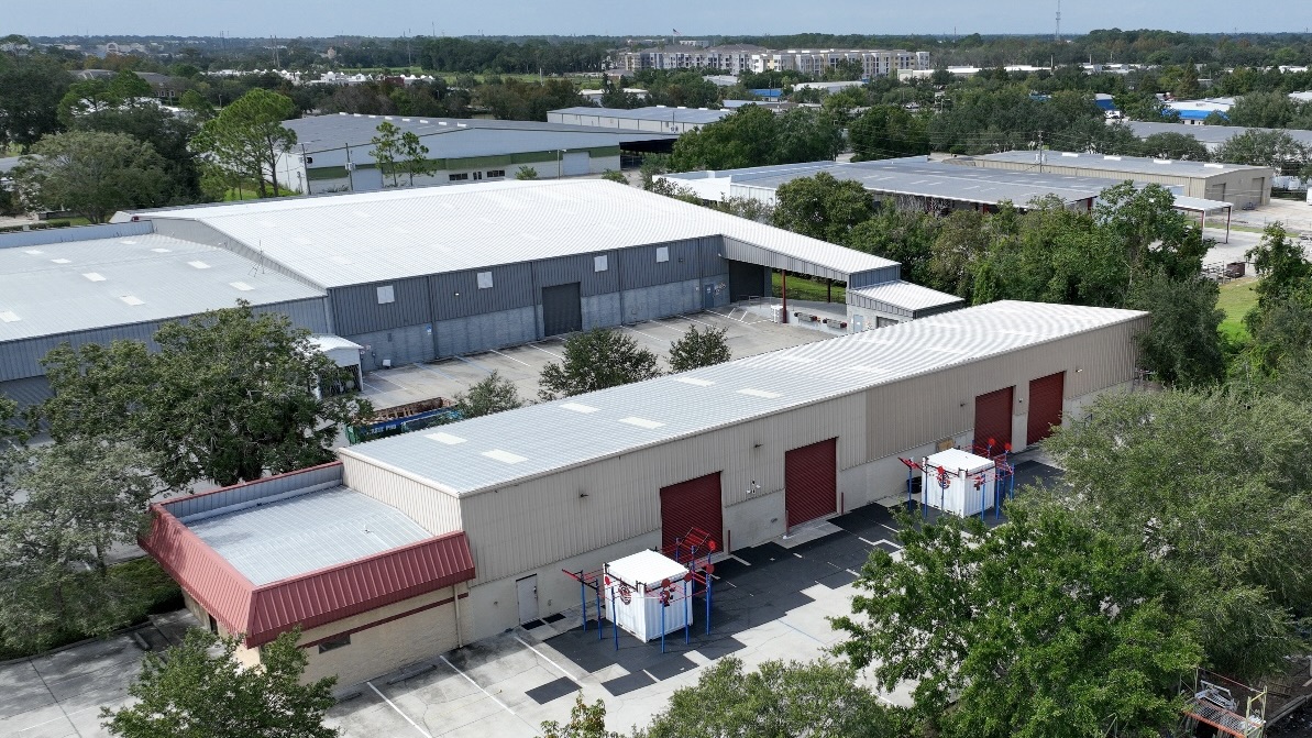
Seeing the whole roof in Amarillo without walking it
A big low-slope commercial roof is hard to inspect well on foot. The sprawling distribution rooftops along the I-40 corridor, the manufacturing buildings out toward the airport, and the long retail roofs around Westgate and Soncy Road can run well past 50,000 square feet, and a crew walking that much membrane takes hours, misses ponding areas that are invisible from standing height, and adds foot traffic to a roof whose condition we have not yet confirmed. We use drone-based inspection to fly the entire surface systematically, capture every drain basin, seam, curb, and penetration in high resolution, and build a complete picture before anyone sets a boot on the deck.
The aerial view is only half of it. Pairing a 4K camera pass with a calibrated thermal sensor lets us find problems the eye cannot see from any vantage point, and it does so across the full roof in a fraction of the time a manual survey would take. For Amarillo property owners and managers carrying several buildings, that speed turns a roof portfolio that used to get inspected once a year into something we can document thoroughly and repeatedly.
Thermal imaging finds the moisture trapped inside the assembly
The most valuable thing a thermal pass produces is a map of where water is hiding inside the roof. Wet insulation holds heat differently than the dry insulation around it. After a sunny day, as the roof radiates that heat back out in the evening, saturated areas stay warm longer and glow against the cooler dry field in the infrared image. That signature shows the exact footprint and extent of trapped moisture inside the assembly even when the membrane on top looks intact and shows no obvious leak.
That single finding drives the most consequential decision on the roof: whether you are looking at a targeted repair, a recover over the existing system, or a full tearoff. Guess wrong and you either overspend on a replacement the roof did not need, or you recover over wet insulation and trap the problem under a brand-new membrane. The thermal map takes the guessing out of it. We confirm the thermal hits with cores or a moisture meter at representative spots so the boundary we draw on the plan reflects what is actually wet, and the reroof scope is sized to reality.
Thermal scanning is genuinely impractical on foot across a large roof. Holding a sensor at the right standoff, at a consistent angle, over an entire commercial deck during the narrow window of ideal ambient conditions is exactly the kind of systematic coverage a drone does well and a person on the roof does not.
No foot traffic on an unknown roof
Walking a roof you have not assessed is a liability in two directions. It risks the crew, because a saturated, weakened, or hail-bruised deck is not always safe to stand on, and it risks the roof, because concentrated foot traffic scuffs membranes and damages older surfacing. Flying the inspection first means we learn the roof's condition before we ever commit people to it. When we do go up for cores or confirmation, we know where the soft spots are and we stay off them.
Documentation adjusters will actually accept
The Texas Panhandle takes a beating from hail and wind, and a clean claim depends on clean documentation. After a storm event in Amarillo, our drone inspection produces GPS-tagged imagery that records hail impact locations and density across the field, wind-related membrane displacement and lifted laps, and damage to rooftop equipment, curbs, and flashings. That format is the kind commercial property adjusters work from, and because every image carries its position, an adjuster can review the roof remotely and verify exactly where each finding sits.
We assemble the imagery into a documentation package suited for direct submission to the carrier, and on contested claims the geotagged record gives you a defensible basis for what was damaged and where. Pre-loss baseline scans are just as useful: a documented condition report before storm season makes it far easier to separate new storm damage from pre-existing wear when a claim comes.
FAA rules and safe operation
Commercial drone work is regulated, and we operate accordingly. Flights are conducted under FAA Part 107 commercial sUAS rules with a certificated remote pilot. Amarillo adds a real airspace wrinkle, because Rick Husband Amarillo International Airport and nearby airfields put portions of the city under controlled airspace where flights require LAANC or prior authorization. We check airspace for every site, secure the authorizations a controlled-airspace location needs, keep the aircraft within visual line of sight, and brief the property contact on the flight plan before we launch so building occupants and ground staff know what to expect.
Better data going into a reroof bid
When a roof is heading toward replacement, the inspection footage does double duty. We use it to confirm roof area measurements, locate every penetration and curb, and document existing conditions for the specification. Bids and drawings built on actual measured conditions, rather than assumptions from a quick walkover, mean fewer surprises, fewer requests for information, and fewer change orders once the work starts. On a multi-building Amarillo campus, that accuracy compounds across every roof in the package.
Where drone inspection earns its keep
- Large flat commercial roofs over roughly 10,000 square feet, where a full walkover is slow and incomplete.
- Distribution, warehouse, and manufacturing rooftops along the I-40 corridor and near the airport.
- Retail centers, office complexes, and multi-building campuses that need consistent, repeatable documentation.
- Post-storm claim documentation after a Panhandle hail or wind event.
- Pre-reroof condition surveys feeding an accurate specification and bid.
What to send us
If you want eyes on a roof in Amarillo, send the building location, the roof type if you know it, and what is prompting the inspection, whether that is a suspected leak, a recent storm, a capital-planning review, or a reroof bid. We will confirm the airspace situation for that location, schedule the flight, and turn the imagery into a report you can act on.
Common questions
How is this different from a walkover? The drone covers the entire roof systematically at a consistent altitude with no foot traffic, and it can run a thermal pass that is not feasible to do well by hand on a large roof.
Can thermal really show trapped water? Yes, under the right evening conditions, and we verify the thermal boundaries with cores or a moisture meter before sizing any scope.
Are you allowed to fly here? We operate under FAA Part 107 with a certificated pilot and obtain LAANC or prior authorization for the controlled airspace around the Amarillo airport.
Which roofs benefit most? Large flat commercial roofs. On small or steeply sloped roofs a manual inspection is already fast and complete.